Drones to the Rescue: How High-Tech Flyers are Saving Our Shared History
- Anton De Vis
- May 27
- 4 min read

Imagine soaring over ancient ruins, peering into the intricate details of a centuries-old cathedral, or exploring a fragile archaeological site without ever leaving your chair. This isn't science fiction; it's the reality of how drone technology is revolutionising the way we protect and understand our world's precious cultural heritage. From the majestic temples of Angkor Wat to the haunting streets of Pompeii, these unmanned aerial vehicles (UAVs) are becoming indispensable guardians of our past.
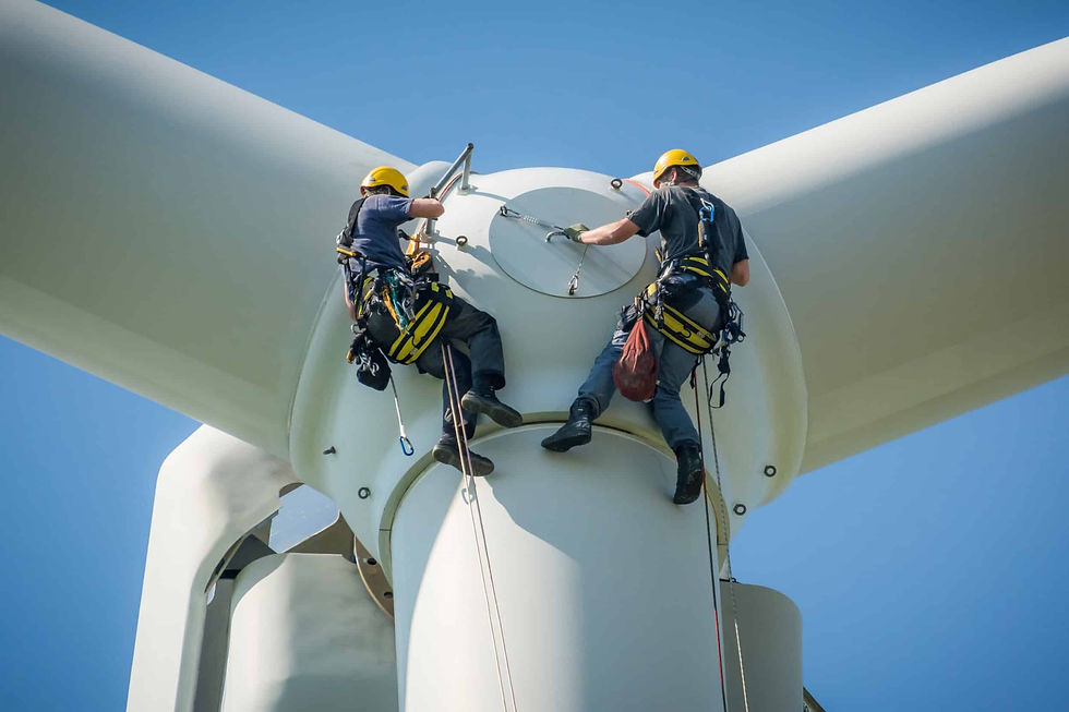
For years, documenting and preserving these irreplaceable sites was a costly, time consuming, and sometimes risky endeavor. Traditional methods often involved scaffolding, manual measurements, and limited perspectives. But now, drones equipped with sophisticated cameras and laser scanners are changing the game, offering a bird's-eye view and a digital toolkit that's transforming heritage management.
Peeking into the Past: The Magic of Photogrammetry and LiDAR
Two key technologies are at the heart of this revolution: photogrammetry and LiDAR.
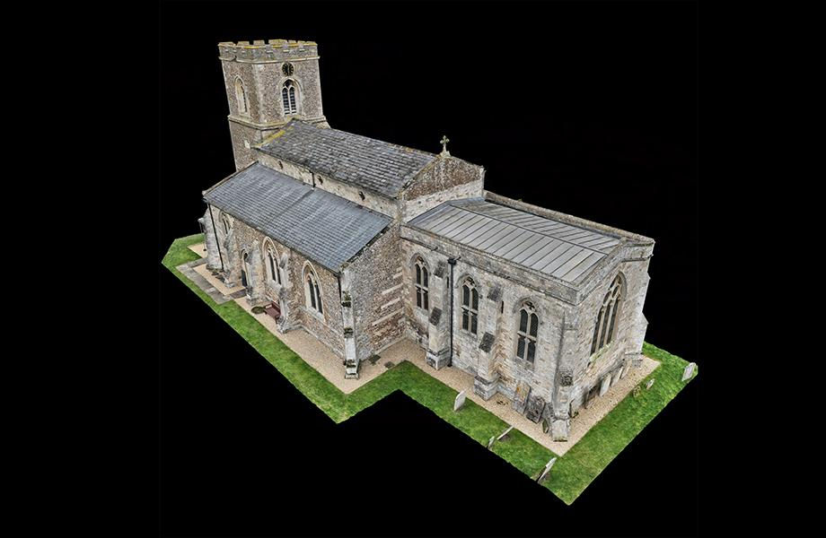
Photogrammetry: Painting with Pictures: Think of photogrammetry as creating a 3D model from thousands of overlapping photographs. Drones systematically fly over a site, capturing high-resolution images from every conceivable angle. Specialized software then "stitches" these images together, much like a digital quilt, to create stunningly detailed and visually rich 3D models and maps. This method excels at capturing the textures and colors of a monument, bringing its digital twin to life.
LiDAR: Seeing with Light: LiDAR (Light Detection and Ranging) takes a different approach. It's an active system that sends out thousands of laser pulses per second. By measuring the precise time it takes for these pulses to bounce back, LiDAR creates an incredibly accurate "point cloud" – a dense collection of 3D coordinates that map the surface of the site with millimeter to centimeter precision. LiDAR is fantastic for capturing complex geometries and can even "see" through some vegetation to map hidden structures.
The beauty of these technologies is that they can be used together. LiDAR can provide the super-accurate geometric skeleton, while photogrammetry adds the realistic skin of color and texture, creating the ultimate digital replica.

More Than Just Pretty Pictures: How Drones Make a Difference
These high-tech 3D models and maps are far more than just digital eye candy. They are powerful tools with transformative applications:
Keeping a Watchful Eye: Condition Assessment & Monitoring:
Imagine being able to spot a tiny crack high up on a cathedral wall before it becomes a major problem. Drones make this possible. The detailed 3D models allow experts to meticulously inspect every nook and cranny, identifying damage like cracks, erosion, or material loss, often in places that are dangerous or impossible to reach by traditional means. By conducting regular drone surveys, conservationists can create a time-series of models (think 3D + time = 4D!) to monitor how a site is changing, track the speed of deterioration, and assess its structural integrity over months or years. This proactive approach allows for early interventions, saving priceless heritage from further decay. For instance, at the Requejo Bridge in Spain, drone inspections helped identify corrosion and material degradation, guiding preventative conservation. Similarly, erosion on the Great Wall of China has been quantified using 3D point clouds.
Planning the Perfect Fix: Guiding Restoration:
When restoration is needed, these digital twins are invaluable. Architects and engineers can use the precise measurements from drone data to plan interventions meticulously. They can even perform "virtual restoration" in a computer environment, testing different repair techniques or reconstructing missing elements digitally before touching the actual structure. This minimizes risks and ensures that physical work is accurate and historically sensitive. At sites like Pompeii and Angkor Wat, drone-derived data has been instrumental in guiding complex restoration projects.1 The detailed 3D model of St Peter and St Paul's Church in Cambridgeshire, UK, for example, has become an "invaluable tool" for planning its maintenance.
A Library for the Ages: Creating Digital Archives:
Drones are helping us build incredibly detailed digital archives of our cultural heritage. These archives – comprising images, point clouds, 3D models, and maps – are a permanent record of a site at a specific moment in time. They are far more comprehensive than traditional photos and drawings and are vital for future research, education, and even for guiding reconstruction if a site is damaged or destroyed by disaster or conflict. The key is to ensure these digital treasures are themselves preserved for the long term, using standards like the FAIR principles (Findable, Accessible, Interoperable, Reusable) and robust data management plans.
Bringing History to Life: Public Engagement & Education:
Perhaps one ofr the most exciting aspects is how drones are making heritage more accessible and engaging for everyone. Those stunning 3D models can be transformed into immersive virtual tours, allowing people worldwide to explore ancient wonders from their computers or VR headsets. Imagine walking through a digitally reconstructed Roman villa or examining the intricate carvings of a Mayan temple up close. This technology breaks down physical barriers and offers new, interactive ways to learn about history and culture.10 Research shows a significant public appetite for such experiences, with drone-enabled virtual tours reportedly boosting online visitor numbers by as much as 25%.
Challenges and the Sky Ahead
Of course, this high-flying technology isn't without its challenges. Processing the vast amounts of data can be complex, and ensuring consistent accuracy requires skill and the right conditions. Regulations for drone use must be navigated, and the initial investment in equipment and training can be a factor.
However, with advancements in Artificial Intelligence (AI) to help automate analysis, ever-improving sensors, and more user-friendly software, the future is bright. AI is already helping to automatically detect cracks in structures from drone imagery and classify different features in vast landscapes.
Drones are more than just a new gadget; they are a transformative force in our quest to understand and protect our shared human story. By giving us new eyes in the sky and powerful digital tools, they are helping to ensure that the wonders of the past can inspire and educate generations to come.